race preview
| home | contact us | movies | galleries | recent stories | archived stories | store |
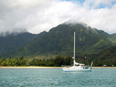
 Skip Allan on the pulpit of Wildflower after finishing the 2008 Singlehanded TransPac. ©2010 norcalsailing.com |
|
Singlehanded TransPac Preview June 14, 2010 With less than a week to go for the 17th running of the biennial SSS Singlehanded TransPac to beautiful Hanalei Bay, Kauai, the question is who is still going and who will win? Race Co-Chair Bob Johnston says the fleet has been whittled down with the impending start deadline. "There are fifteen boats still standing. Attrition has been due mostly to the high proportion of first-time SHTP'ers - only four race veterans are entered and the preparation the first time is daunting. You've probably heard his quote - hearing that Phil MacFarlane had done a solo race to Hawaii, a friend asked him, 'At what point were you completely and utterly exhausted?' Phil answered 'About three days before the start!'" After all the prep the actual racing should be good, and the corrected overall winner is not an easy pick. Who would you place your bet on? Win, Place and Show? Bob has to be impartial, but he has some ideas. "I can say that Ronnie Simpson on Warriors Wish has been practicing hard and is very serious, which impresses me. Adam Correa with his 'turboed' International Folkboat Blue Moon is equally focused. The continuing SSS rivalry between Taz!! and Mirage will be fun to watch. Jeff Lebesch on Hecla burned up the ocean during the LongPac (look at the time spreads) and will have an impressive run (and hopefully first to finish). The WylieCat is always an unknown, and he has spinnakers! The Westsail 32 Saraband is immaculately prepared and has an impressive Pacific Cup win in his background (1988 I think, did very well even on elapsed time). If he does well, Adrian on Idefix could be the third Olson 30 in succession to win the beautiful Tallet Memorial trophy for first corrected boat from outside Northern California. Foolish Muse (WA) won it in 2006 and Polar Bear (MN) won it in 2008. The corresponding Latitude 38 trophy for first corrected-time monohull from Northern California, won by Wildflower in 2008, who knows?" And speaking of Wildflower, Skip Allan may be sitting on shore this time, but his thoughts and routing information are with the racers. His wisdom is posted on the SSS website forums and makes entertaining reading for all us sailing nerds. And so we reproduce it here with Skip's permission. This is an extremely complete and in-depth report, and so is broken into multiple pages. Read and learn… 2010 SHTP Bug Lighters: In tribute to Wildflower, my partner in the 1978 and 2008 Singlehanded TransPacs, I am posting a multi-part weather/tactical discussion based on first-hand experience in 28 West Coast-Hawaiian Races since 1961. I would welcome others' experiences and questions. All courses noted are given in magnetic degrees.
PRE-RACE WEATHER/TACTICAL PREP Though the main goal of racing SHTP is the challenge of making a safe and fun ocean crossing, much of the pleasure of the SHTP is arriving at Hanalei in a timely manner. Reunions with family, friends, and competitors, Tree Time, and enjoying the pleasures of tropical Kauai are all incentives for a fast passage. Not to mention the race deadline of 21 days. SHTP requires a basic understanding of weather conditions from start to finish, and how best to use them to advantage. An excellent overall view is Stan Honey's "Slotcars to Hawaii," available online. Jim Corenman's treatise in the Pacific Cup Handbook is also an excellent resource. First hand SHTP weather stories, such as related in the Crawfords' Black Feathers, as well as past SSS Forum posts and logs from previous SHTPs can be mined for information. The most thorough understanding of SHTP weather, and relevant tactics, is only as valuable as the route chosen. A simple but comprehensive GAME PLAN is invaluable. The GAME PLAN is based on forecasts and real time observations before leaving the dock. A skipper with a GAME PLAN will arrive sooner than one zig-zagging down the race track, sailing extra miles. The GAME PLAN is not set in cement, but can and should be adjusted daily according to such variables as: movement of the EPAC (Eastern PACific) High, tropical waves passing to the south, and other competitors' positions and weather. The Great Circle (GC) to Hanalei, as shown on your GPS, is the shortest course. But the GC is rarely the fastest. The GC takes one north into the calms of the EPAC High. If the GC were flipped upside down, the resulting "Reverse S" course, pioneered in the '49 San Pedro to Honolulu Transpac, would more likely approximate a successful route, at least for the first half of the SHTP. The GAME PLAN can be broken into sub-plans:
The GAME PLAN should also take into account possible variations and anomalies, such as:
For this year's 2010 SHTP, there is a weakening El Nino. This El Nino should become neutral by June/July. A non-existent El Nino means late spring storms should track further north, and likely not have as much potential influence on the SHTP course as during an El Nino year. In non-El Nino years, the EPAC High becomes the predominant weather feature of the EPAC in early July, two weeks after this year's start. 2010 competitors can thank SSS Commodore Bill Merrick and SHTP RC Co-Chair Bob Johnston for scheduling this year's SHTP for maximum moon, something the Pacific Cuppers three weeks later will not have in their favor. Full moon is June 26, or about halfway. Bug Lighters are blessed, as a bright moon makes the passage infinitely more enjoyable. And safer. Nevertheless, there will be dark nights. For apparent wind direction, nothing beats an aft facing Windex at the masthead, lit by a tri-color light. Also, white nylon spinnaker cloth telltales, hot knifed into 1"x16" strips from sailmaker's scraps, and lit by a flashlight or headlamp, serve much better than wet or dark yarn. Even toilet paper taped to the weather shrouds makes an inexpensive night (or light air) wind instrument. I like to tape over the steaming light, leaving just a slit to light the fore triangle during dark squalls. A dimmer switch on the steaming light is a more high-tech alternative. For those relying on wind instruments, two thoughts: Wind instruments are only as good as the calibration and lighting. When sailing off the wind, if the instrument wand is facing forward, it may suffer directional interference from the masthead and/or spinnaker upwash. Word to the Wise: The compass light will fail at some point. Take a couple of spares that can be easily plugged in. And when the compass light does fail, don't place a flashlight near the compass. Further Thoughts on Prep: COLD: If the hardest part of the SHTP is untying the docklines, the second hardest is the first night at sea. Prepare for cold, wet, and rough the first couple of nights, with thermals, fleece, good foulies, and clothing redundancies. Decisions made when wet, tired, or seasick can be compromised, and errors compounded. Cloud cover out to 135 degrees W is the rule, not the exception. In the '08 SHTP we did not see the sun until Day 8. DRY: Importance should be given to having a dry and dedicated weather/nav area. This can be as simple as a portable lap board. Readily accessible, besides the SF-Hawaii chart, cut/folded to cover the course, is a second chart with winning tracks from previous SHTPs and Pacific Cups. In absence of a chart plotter, a pad of plotting sheets (available for less than $10) is good value. Plotting sheets can be lined at the appropriate latitude, and 10 degree increments of longitude. Call me old fashioned, but on a small boat with limited electrics and a vulnerable and power hungry computer, I use plotting sheets to plot my course, positions of fellow competitors, note sail changes, barometer readings, plot downwind jibe angles, etc. Ultimately, these plotting sheets, 4 or 5 for the course, act as my hard copy log of the race for current and future review. HOT: As the fleet passes halfway and sails SW into summer, the sun will be almost directly overhead at Local Apparent Noon (LAN). Being on deck without shade can be debilitating. An umbrella clamped to a stanchion or small awning/bimini, a good sun hat, a fan over the bunk, and a flower misting squirt bottle all become invaluable. For the second half of the SHTP, consuming 1 gallon of water/day was my norm to stay hydrated. SLOW: From the start out 200 miles to 125W, loose kelp, and to lesser extent kelp paddies, can hang up on keels, rudders, props and struts, causing degradation of speed. Further west, out past 135W, and increasing approaching Hawaiian waters, all manner of plastic debris, monofiliament nets, net islands, and polypro rope become obstacles. 25-50% of SHTP competitors will likely snag something, and may not realize the problem, especially if an autopilot or windvane is steering. Absent bottom windows, kelp cutters, or an expensive and fragile endoscope, there are several clues that something has hung up: 1) By disconnecting the windvane/AP and hand steering once an hour, one is more likely to feel vibration caused by snagged debris. 2) By charting hourly average speed and distance, it is more likely to notice a slowing in boatspeed. 3) By heeling or broaching the boat and hanging over the side, sometimes trailing debris can be visually seen. As preventive maintenance, at noon every day, I would back down Wildflower. The peace of mind was worth the approximately two minutes lost to perform this maneuver, which usually involved dropping the jib, twins, or spinnaker, and backing the main with a preventer. The other 'in extremis' alternative, not recommended for solo sailors, entails 'parking' the boat by lowering all sails, deploying a drogue, using a long tether and swim ladder, and donning mask and fins. PRESSURE: A calibrated barometer, even wrist watch style, is a must for the SHTP, and return passage. Calibrate to Oakland airport reading prior to start. Save time: rather than recalibrating, simply note error on the barometer, to be added or subtracted when logged. Pressure readings, logged at four or six hour intervals, can be a significant tool in reconciling observed weather with weather fax charts, GRIB files, WWV reports, approaching tropicals, etc. Most importantly, the barometer gives confidence in routing around the EPAC High. GUEST NAVIGATOR: The choice of a "Guest Navigator" (or navigators) can and should be made by each competitor. After the SHTP start, NO WEATHER or ROUTING INFO may be relayed from wives, friends or weather routing sources. However, competitors' ROLL CALL POSITIONS, COURSE and SPEED only, may be relayed from shore stations via email/ Sat Com voice, or SSB/ham. Wind/sea reports can be exchanged between competitors via VHF or SSB public channels. There is no shame in pre-identifying experienced TransPac competitors and keying off their daily roll call positions and courses. This is your "Guest Navigator." In 2008, I chose Alchera, Polar Bear, and Haulback as Wildflower's "Guest Navigators." All three had strong SSB signals, and two were previous SHTP overall winners. Not by accident, Polar Bear and Wildflower's tracks were ultimately similar. Though Polar Bear was over 100 miles ahead at halfway, it was a confidence builder running in Eric's wake, knowing he was sailing in good wind. Alchera, ahead and initially on a more northerly track, was my 'probe' for wind conditions closer to the EPAC High. NEXT CHAPTER: Day of the Start (June 19, 2010) PART 1: EXITING SF BAY Wi-Fi Internet access is available in the vicinity of Corinthian Yacht Club, an invaluable tool for pre-race GAME PLANNING. PassageWeather.com gives winds, sea, and pressure forecast charts in vivid color out to seven days, (remember to subtract seven hours from UTC for local time). The Farallon Islands have a webcam which also gives current wind speed and direction. With many weather tools available, and pre-race distractions walking the CYC docks, GAME PLANNING can become overwhelming. The key is keeping it simple, writing in a notebook, and not getting too far ahead. Weather forecasts, quite reliable inside 72 hours, begin to degrade in reliability outside 3-5 days. Routing programs and suggested courses from professional services, though helpful in seeing the big picture, can be misleading and take competitors too close to the EPAC High. With racers' prop shafts sealed, CYC graciously offers towing to all boats the morning of SHTP start. Smaller boats may chose to sail off the dock. Starts will be on an ebb tide, three hours before slack current at Golden Gate Bridge (1410), and six hours before max flood (1715). This tide cycle nicely avoids beating into a building flood tide in late afternoon. SHTP competitors unfamiliar with the race course from the CYC start as far as Mile Rock/Pt. Bonita should practice navigating that area. Clearing SF Bay and its obstructions, traffic, wind and tidal zones is not trivial. Equally important, a small separation of boats in the first 10 miles can accordion into hours, even days of advantage at the Finish. Not being clear of land by nightfall can make for a long first night at sea as the afternoon seabreeze dies at sunset near shore, and fades westward into the Gulf of the Farallones by midnight. There is significant snow melt runoff this year. This freshwater runoff increases the surface ebb tide, and delays the flood tide. The fastest outgoing (and most favorable) tide will be in the choppiest and muddiest (brown) water, in contrast to flood tide, which is more green/blue ocean water. Deeper water will have more favorable ebb current until at least 1430 hours. A depth sounder is a good tactical tool early in the Race. Visually, tide lines can be quite distinct. Race day's ebb tide will have the effect of increasing apparent wind by several knots as boats are set westward. Inside SF Bay, the SW-W seabreeze begins to build by 1100, reaching max velocity of 20-25 knots or greater between 1300-1600 hours. The most wind will be just E of the GG Bridge where land narrows the channel and funnels the wind and current. Outside SF Bay, the afternoon sea breeze builds a little later and can often be seen as a whitecapped windline approaching from the NW. The seabreeze veers from SW to W during the afternoon, favoring boats north of the Bar Channel on the inside of the lift. Although June can be the windiest month inside SF Bay, the inboard (N) end of the CYC start line lies in the lee of Belvedere Peninsula, resulting in light and swirling winds in this area. Consider starting near the outboard (southerly) end of the line, which is closer to the building windline funneling in through the Golden Gate, and in more favorable tide. Due to the ebb tide, if it is light wind at the start, racers run the risk of being swept across the line early. Be sure to make a pre-start current check at the outboard end inflatable starting buoy. A range transit on the CYC flagpole and clubhouse in the background can be used effectively to tell when one is near or on the start line. Just south of the start line, Angel Island is steep-to on its north and western shores. Lighter winds and starboard tack headers are found close aboard Angel Island as the westerly seabreeze lifts up over Angel. From the Start, if not laying Angel Island on starboard tack, I would suggest sailing closehauled up to Pt. Stuart before tacking to port. This has the benefit of catching the (ebb) tidal race in this vicinity and being set boldly to windward. Again, practice will pay dividends. Especially if practice sails are made during similar tidal cycles to the morning/afternoon of June 19. Crossing SF Bay, the wind is likely to make up quickly, catching the unaware with the wrong sail combo. The first jib change/reef, shortly after the start, with the lee rail awash and spectator traffic photographing from close aboard, is not a pleasant prospect, but should be anticipated. Outside the Golden Gate there is often less wind, more lump, more low clouds and fog, and lower visibility, leaving competitors initially overdressed and underpowered. A friend with a cell phone, stationed on the Marin Headlands or Lands End, can give wind, sea, and visibility reports to competitors before the preparatory signal. Again, no private weather info may be received from shore after racing commences, not even "Honey, it's windy out here, I'm freezing, and I can't see you!" Commercial shipping, inbound or outbound, will cross the SHTP fleet at some point early in the Race. Although Bar Pilots and the Vessel Traffic Service (VTS) will be aware of the outbound SHTP Fleet, COMMERCIAL SHIPPING HAS RIGHT-OF-WAY AND SHTP RACERS MUST STAY CLEAR. In addition, COLREGS Rule 10 states that "so far as practicable, a vessel shall cross a traffic lane on a heading as nearly as practicable at right angles to the general direction of traffic flow." Anticipation is key. VHF Channel 14 is used by VTS for all commercial vessel movement within SF Bay. VHF Channel 12 is used by VTS for shipping in the three coastal traffic lanes and within a six mile radius of the 'Lightship' (San Francisco Sea Buoy.) Updates on ship movements outside SF Bay are given at 15 and 45 minutes after the hour by VTS on VHF 12. What will be heard is commercial vessel name, bearing and range from the San Francisco Sea Buoy, course and speed, and ETA information. AIS also is an invaluable tool near shore. But AIS is visual rather than audible, and likely requires going below into a darkened and bouncing cabin to see what's coming. Inbound commercial shipping, after picking up a pilot near the Lightship, will be coming down the narrow and buoyed Bar Channel at speeds of 12-20 knots. Commercial ships passing abreast constricts the Channel further. Inbound shipping slows to 12 knots in the vicinity of the Golden Gate Bridge and crosses under the bridge near Center Span. Inbound shipping then stays on the Cityfront (SW) side of the Bay. Outbound shipping leaves Alcatraz to port, Harding Rock Buoy to Port, and Angel Island to starboard, before turning to port for Center Span of the bridge. Outbound shipping in the Bay will be traveling at speeds to 12 knots, before accelerating to full speed once under the bridge. High speed passenger ferries and chubby Red and White tour boats have sail savvy captains, and will attempt to stay clear of SHTP racers. Tug and tow are wildcards, often slowing to adjust towlines in SF Bay Approaches. Tugs without tow shepherd all transiting tank ships, and these tugs are usually positioned close astern of the ship. Pilot vessels are orange. Close encounters with slow moving or stationary fishing vessels should be avoided at all costs. Suggested reading is USCG's Vessel Traffic Service San Francisco User's Manual, available at www.uscg.mil/d11/vtssf/vtssfum.asp. GAME PLAN recommendation for Exiting SF Bay on Race Day is: In ABSENCE OF SHIPPING, stay in deep water in center Channel for best ebb, and away from bays near the shoreline, where the early flood will be. In PRESENCE OF SHIPPING, stay out of the Channel and well clear. The start will likely be in light airs and wide variations of wind direction/speed near the start line will likely prevail. Don't be early, don't be late. Be prepared for building breeze after 1100. And keep jib sheets clear and flaked so as not being caught aback in an unplanned tack thrown at you by the South Tower Demon, or his brother who lives over at the North Tower of the Golden Gate Bridge. PART 2: CROSSING the GULF of the FARALLONES With the Golden Gate astern, a line between Pt. Bonita on the N side of the Channel and Mile Rock to the S marks the entrance to the Gulf of the Farallones. Both Bonita and Mile Rock have washing machine conditions close aboard, with square waves caused by tidal rips in their vicinity. They are best left at a distance of .25 mi or more on Race Day. However, .25 mi distance off from Bonita or Mile Rocks puts one very close to East and West Bound Traffic Lanes. And navigators must be alert for possible oncoming shipping and stay clear of whichever lane(s) is/are being transited. The Gulf of the Farallones begins with a shoal expanse of coastal water westward to the horseshoe-shaped San Francisco Bar. The San Francisco Bar Channel (Main Ship Channel) bisects the Bar and is dredged to a control depth of 55 feet. The Bar Channel is 2,000 feet wide, and marked by eight buoys, four red, four green. On the horseshoe-shaped Bar, outside the Shipping Channel, the water depth is 20-30 feet less: about 25-35 feet over the North Bar, and 35 feet over the South Bar. This is shoal water indeed, and during winter, spring, and fall, the SF Bar can break heavily and dangerously. Luckily for SHTP racers, the Bar rarely breaks during June-August, and can be transited with caution at any point outside the Shipping Channel, as long as the latent swell is 10 feet or less. Unless there is zero commercial traffic in the vicinity, SHTP racers really should stay out of the Main Ship Channel as far as the Lightship. (The Lightship is no longer a lightship, but a large red/white navigational buoy marked "SF" where the pilot vessels hang out.) Commercial shipping slows to steerage in the vicinity of the Lightship to briefly embark or disembark their pilots, using the NW, SW, or S designated traffic lanes as their approach or departure. Experienced local racers take advantage of an ebb tide by staying in the deepest water on the edges of the Channel, just outside the Channel buoys. If all goes well, the SHTP fleet should be in the vicinity of the Lightship, perhaps several miles south, at about 1500 hours. West of the Lightship, the heave of the ocean swell begins to be felt. It is 26 miles, 240 degrees m from the GG Bridge to the vicinity of the SE Farallon Island. In most SHTP races, the Farallones are left to starboard at an approximate distance of 5-7 miles. This is because an approximate course to Point A on the SE lobe of the EPAC High is around 225m. For practical purposes, until the building WNW afternoon seabreeze fills and one can steer a consistent 225m, SE Farallon should be considered the 'windward mark'. This is a better proposition than leaving SF Bay, turning left at Lands End, setting the self steering, and languishing in lighter airs near Pt. Montara overnight. Fog and low clouds predominate in the Gulf of the Farallones in June. The SE Farallon may not even be sighted. Bird and sealife in the area is plentiful. In the '08 SHTP a sea lion came aboard Ankle Biter for a visit, and Alan had to discourage the pinniped and defend his ship by snapping a foulie jacket. In the Gulf of the Farallones, ocean swells are topped with short steep wind chop any time the wind gets above 16-18 knots. If all goes well, the majority of the SHTP fleet should be south of the Farallones by dark, on starboard tack, with sheets beginning to be eased on a close reach, as they head for Pt. A, 450 miles, and 3-4 days to the SW. But not quite so fast. 25% of races from SF to Hawaii experience a 'Southerly Surge' or reversal of the predominant NW wind in near shore waters. A 'Southerly Surge' is a weather phenomenon that begins in Southern California, usually at the end of a heat wave, and migrates up the California Coast at a speed of 15-20 knots. It is characterized by stratus, low clouds, fog, and light winds from the SW through SE. Southerly Surges are very visible on satellite photos before the start. They are also characterized by rapid reversal of wind direction, from NW to S at coastal and near shore weather buoys. Southerly Surges were experienced at the starts of the '06 and '08 SHTP, making for light airs, even drifting as the fleet crossed the Gulf of the Farallones and beyond. The problem with a Southerly Surge event is Hawaii is dead to windward. Port tack takes you in the direction of Alaska, and starboard towards Mexico. Some racers in Southerly Surges have passed Pt. Reyes close aboard. Others have seen the lights of Half Moon Bay. The influence of a Southerly Surge can be felt for several hundred miles, as far west as 124-125 W, where a transition to the normal NW gradient wind from the NW is made. What to do if a Southerly Surge is occuring or in the forecast? First, know that your race will be slowed by 1-2 days at the outset, and shipping extra water before leaving the dock may be a prudent call. Second, put on your light air thinking cap, toilet paper telltales, and hand steer as much as you can, because most autopilots and windvanes will not respond well to the light and variable winds of a Southerly Surge. Lastly, get west as fast as possible, because a Southerly Surge will eventually dissipate, usually beginning from the north and extending to the south. Boats positioned to the north and west usually will get the new wind first. GAME PLAN for crossing the Gulf of the Farallones: When leaving the Golden Gate, consider the SE Farallon Island the windward mark until such time as a course of 225m can be made. If the forecast is for NW winds 10-20, or 15-25, initially be on the north side of the Main Shipping Channel to meet this wind first. Be alert for shipping in the Gulf of the Farallones. If a Southerly Surge event is occuring, all bets are off and timing is going to be delayed.
|
||||||||